Wars are often narrated through singular events: an airstrike, a massacre, a ceasefire, or a military operation. Yet the cumulative logic of violence is frequently obscured. Taken in isolation, attacks may appear exceptional; read across time and space, they reveal persistent patterns of targeting, destruction, displacement, and territorial control.
In numerous villages and towns across Lebanon, Israel has killed hundreds of civilians alongside daily attacks on homes, infrastructures, and landscapes since the declaration of the so-called ceasefire deal in November 2024 following a 66-day brutal escalation.
On 2 March 2026, a second wave of escalation started, marked by intensified Israeli attacks across Lebanon, mass evacuation threats, and the expansion of military positions inside Lebanese territory. On 17 April, another so-called ceasefire took effect, but since then, Israeli forces have carried out widespread collective demolitions across border towns under what they termed the “Yellow Line” or “Security Zone,” occupying villages, demolishing homes, bulldozing roads, uprooting trees, and destroying cultural and religious landmarks, while continuing intensive daily artillery shelling and aerial bombardments across other southern areas.
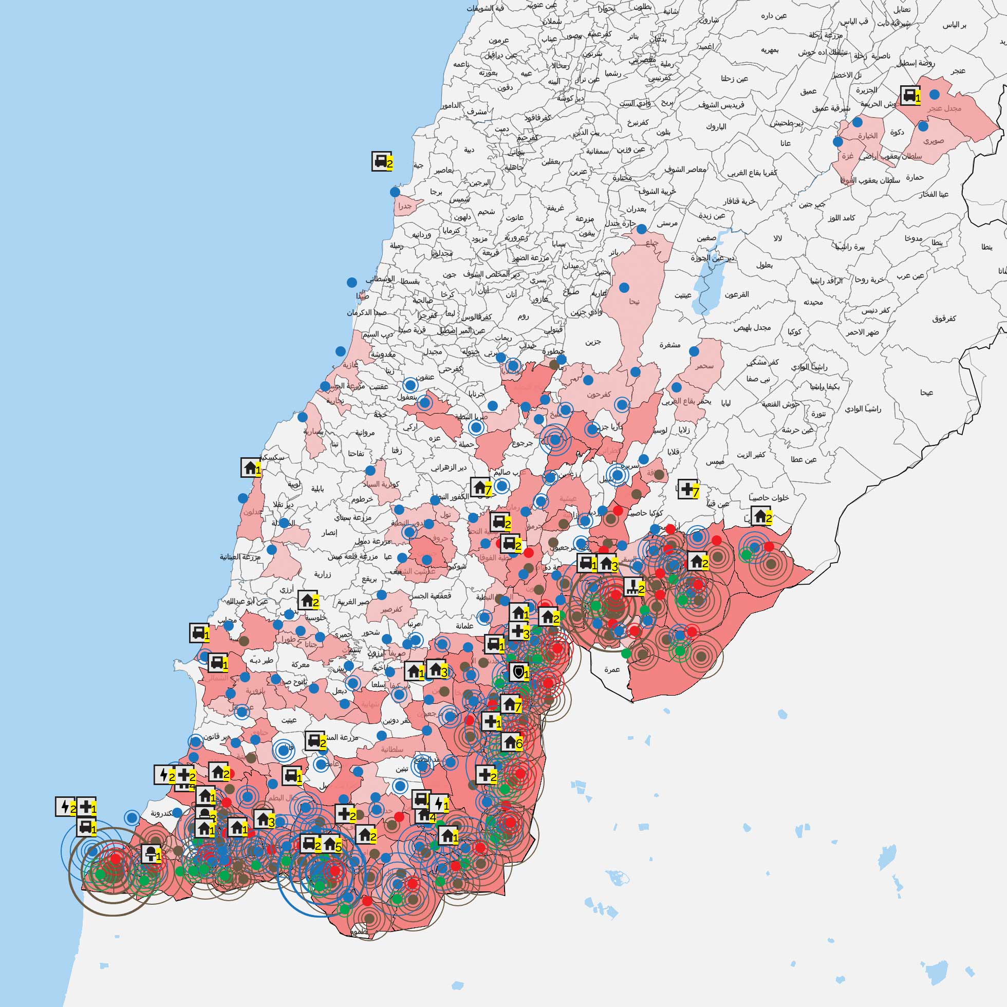
Since October 8 2023, Public Works has been recording the israeli bombardment of Lebanon and mapping the raids according to the type of weaponry; the number of days of bombardment; and the types of targets. This article presents some of the readings of these monitoring and mapping efforts while framing this documentation as a tool to challenge dominant colonial narratives.

Reading the Israeli Attacks on Lebanon Since 2023
With the renewed military aggression on Monday, 2 March 2026, the Israeli occupation forces targeted more than 250 towns across Lebanon, carrying out 1,623 attacks during the period up to Thursday, 12 March 2026, coupled with mass evacuation orders issued by the spokesperson of the occupation army. These threats covered 278 towns, amounting to approximately 1,489 km², representing 14.25% of Lebanon’s total territory.
Homes and civilian buildings have been the primary targets in this escalation. Israeli forces have repeatedly struck residential neighborhoods and families inside their homes, causing massacres that have killed dozens of civilians. On the ground, Israeli forces established 13 additional military posts inside Lebanese territory, bringing the total number to 18 posts, while continuing to threaten a large-scale ground invasion.
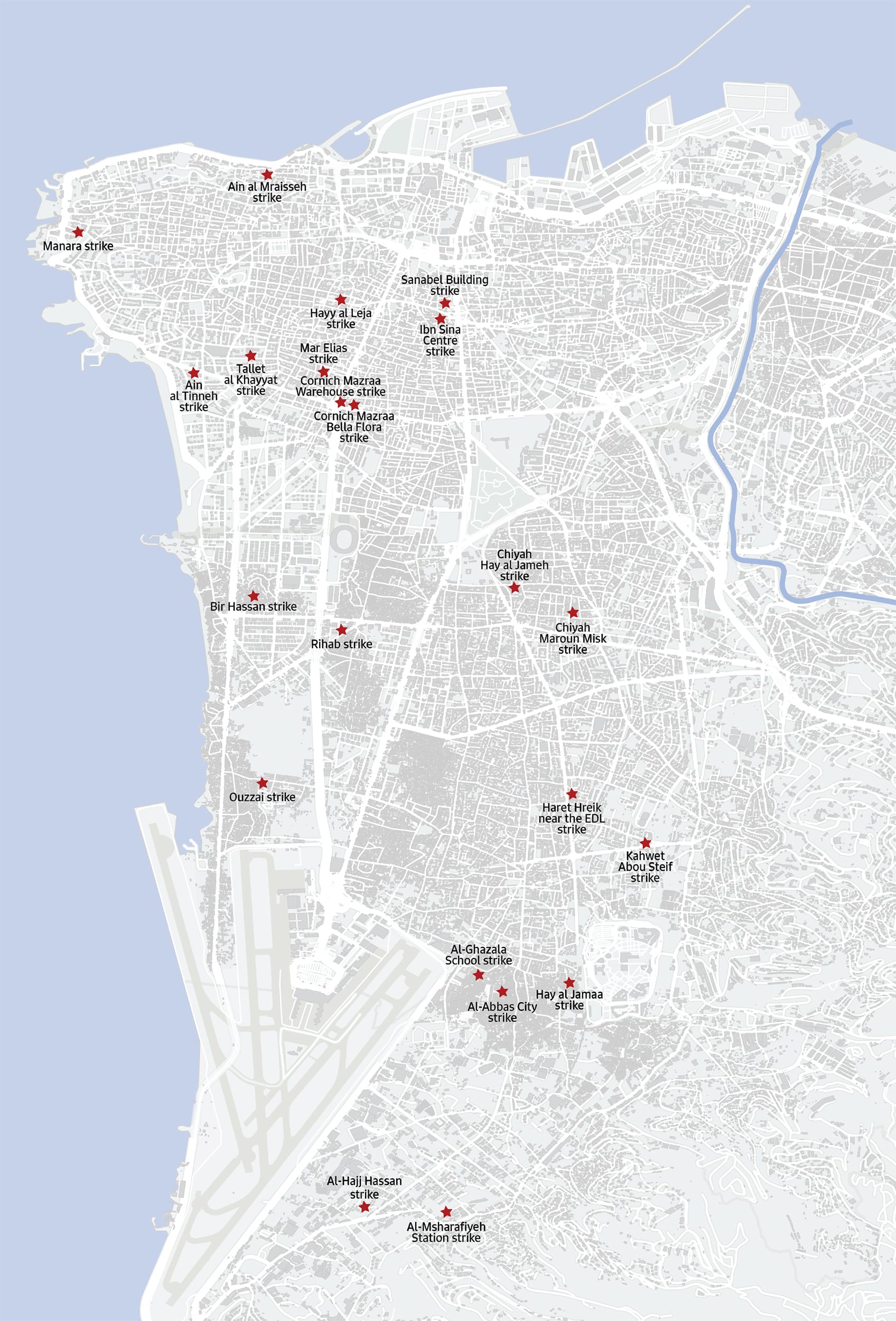
On Wednesday, April 8, 2026, the occupation carried out the largest massacre committed by israelis on lebanese citizens, launching 100 airstrikes in less than 10 minutes, killing more than 357 people (including 30 children and 71 women) and wounding 1,223 others (including 142 children and 358 women), according to a preliminary toll issued by the Ministry of Health.
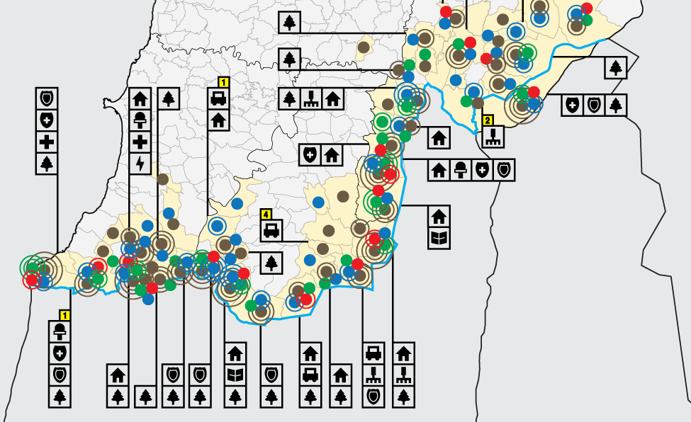
However, Israeli aggressions did not start on the second of March 2026. They have been a prolonged condition since 8 October 2023. In fact, in the first three months of the aggression, forests, woodlands, and agricultural lands topped the list of the most heavily bombarded targets, suffering severe damage that included the killing of livestock and poultry and the burning of green areas. These attacks align with a broader Israeli strategy to destroy Lebanon’s ecosystems, recognizing their role in sustaining communities and their resilience.
In the months that followed, starting in December 2023, there was a clear shift in the pattern of attacks. The number of days in which forests and agricultural lands were targeted decreased, while the bombardment of residential neighborhoods, homes and infrastructure intensified.
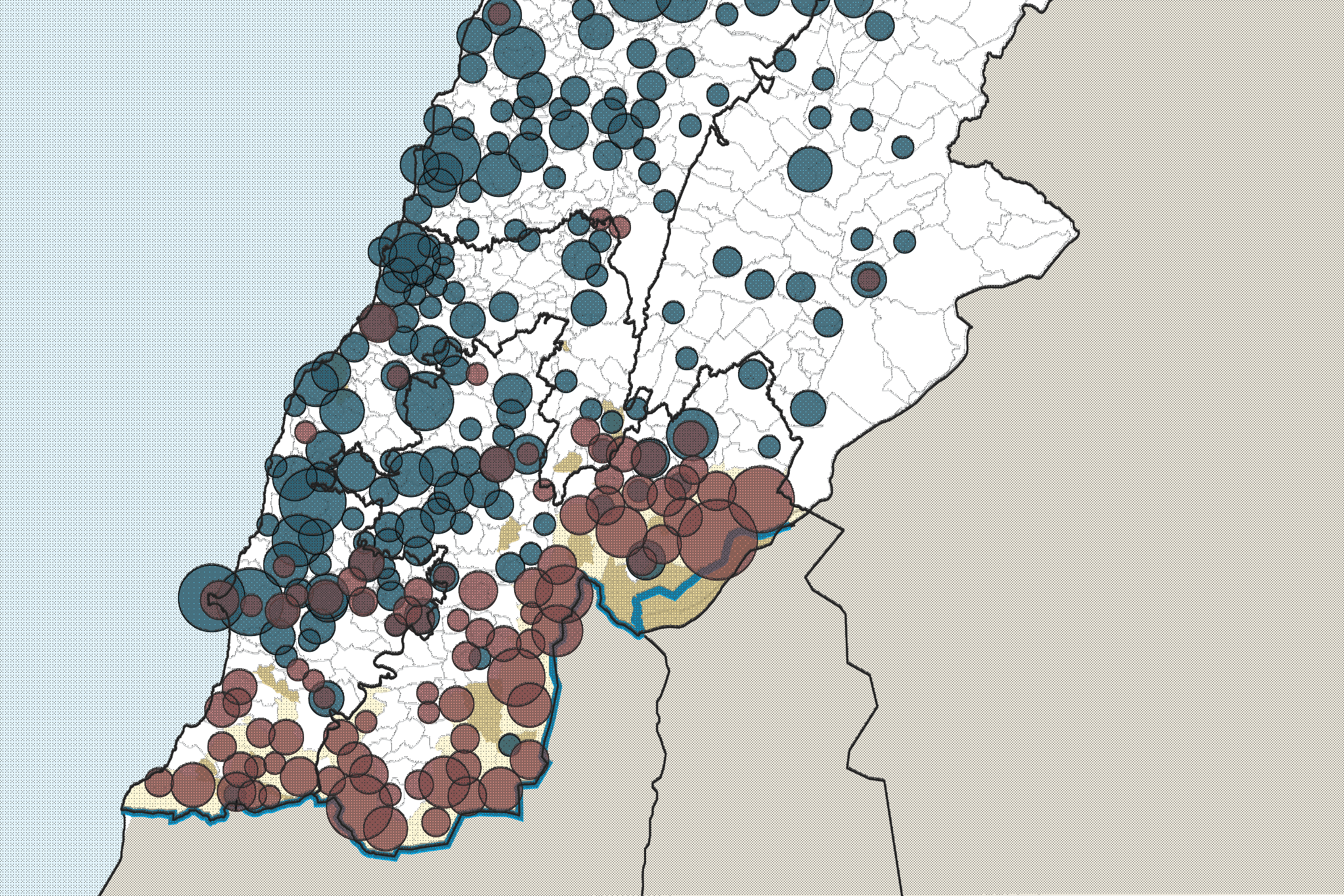
With the almost total absence of media coverage back then, and the Lebanese state denying that we were in a state of war, the below timeline represents the number of areas in Lebanon hit by Israeli strikes per day long before the first escalation of September 2024.

Reading the Attacks by Type of Target: health facilities as an example
Public Works Studio has been documenting Israeli attacks on Lebanese territory and its residents through an interactive open map that is updated daily. Based on continuously verified data gathered from multiple media sources, the map provides a documented record of the attacks, the types of weaponry used, and the targets affected, while offering a tool for exploring their geographical distribution and chronology across the country.
When analyzing the map based on the type of target, we can conclude that there have been systematic attacks on specific facilities, such as health facilities.
Since the start of the war and during the ceasefires, up until 18 May 2026, the Israeli occupation has killed more than 338 paramedics and injured 593, systematically targeting ambulance teams and their vehicles, in addition to hospitals and healthcare facilities. This systematic targeting is part of the occupation’s broader strategy to undermine humanitarian and medical services in the targeted areas.
Public Works documented 162 direct assaults on paramedics during this period as they carried out their duties, including evacuating the injured, clearing debris, firefighting, and assessing the effects of airstrikes. The occupation also targeted ambulances and fire trucks, as well as 125 medical centers, emergency points, and clinics. Moreover, attacks were directed at hospitals or their surroundings, causing significant damage to more than 16 hospitals and forcing some to cease operations.

2023 – 2024 South Lebanon: Phosphorus, Detonation, Prohibition of return
Public Works Studio has been documenting Israeli attacks on Lebanese territory and its residents through an interactive open map that is updated daily. Based on continuously verified data gathered from multiple media sources, the map provides a documented record of the attacks, the types of weaponry used, and the targets affected, while offering a tool for exploring their geographical distribution and chronology across the country.
1- Phosphorus
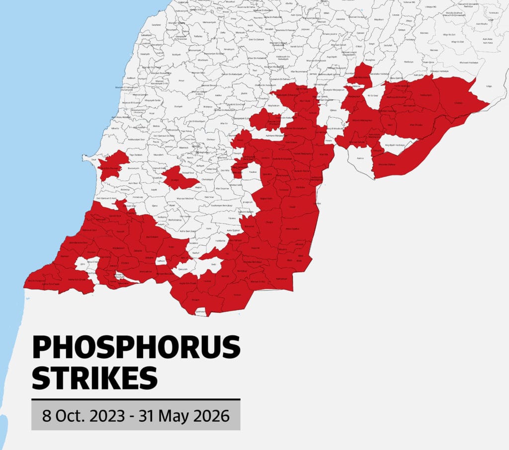
Since October 8, 2023, Israel has fired more than 397 phosphorus shells, directly affecting both people and the environment, leaving long-term health and ecological damage. In its latest escalation, Israel has continued to use internationally prohibited white phosphorus, with strikes recorded between March 2 and 17 May 2026 in 36 areas.
2- Detonation
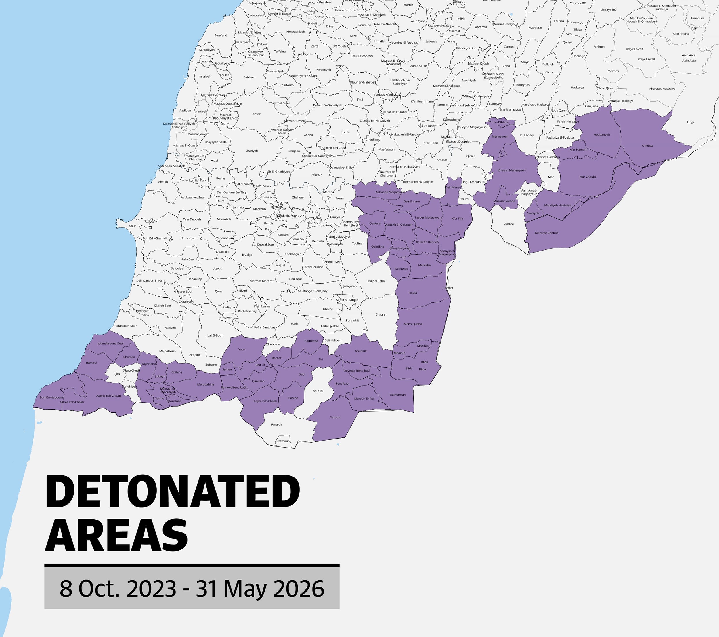
The widespread use of explosives and planned large-scale demolitions have targeted entire villages and neighborhoods; entire urban fabrics in 54 towns have been booby-trapped and detonated, in a form of urbicide that goes beyond destroying buildings to erasing individual and collective memory and eliminating spatial narratives, both historical and contemporary .
3- Prohibition of return
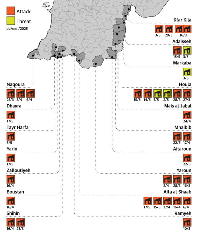
Following the announcement of the first ceasefire on 27 November 2024, the occupation escalated its aggression by targeting every possibility toward return and reconstruction, systematically striking the essential elements needed to restore daily life in the affected areas. The attacks initially focused on vehicles and bulldozers involved in rubble removal, road clearing, and land rehabilitation. Later, as residents began rebuilding their homes and returning to their villages, the attacks expanded to target construction sites and prefabricated homes. Attacks were also recorded against quarries, stone and aluminum plants, and lumber mills that provide essential materials for reconstruction. Even engineers surveying the damage, laying the technical and organizational groundwork for reconstruction projects, and participating in related discussions were not spared from the occupation’s attacks. Up until 19 March 2026, 110 such attacks have been recorded.
2024- 2026 The Urbicide of southern Beirut
Southern Beirut was first targeted on 2 January 2024, in an assassination inside a residential building. After several subsequent strikes throughout 2024, the Israeli military adopted what they called “threat maps” in the area, starting 27 September 2024. Published nearly daily -often after midnight- these warnings gave residents only minutes to flee, in fact preventing the safe evacuation of families.
Up until the ceasefire was declared on 27 November 2024, Beirut and its suburbs were targeted by around 500 airstrikes, 279 of which were preceded by threat warnings, in addition to thirteen airstrikes carried out after the ceasefire took effect.
The airstrikes caused extensive damage to civilian infrastructure, targeting 101 out of 128 public and private educational facilities (91%) and approximately 27 out of 35 healthcare facilities. Major markets in Chiyah, Bourj el-Barajneh, and Sainte Thérèse were heavily damaged-particularly in Haret Hreik, where 80% of shops sustained partial damage and more than 30% were completely destroyed, while over 16 residential complexes were struck, causing widespread destruction to homes and apartments.
On the dawn of Monday 2 March 2026, residents of southern Beirut awoke to the sound of a sudden Israeli barrage, which marked the start of the second wave of escalation against Lebanon. In the 38 days following that night, Beirut was hit by a further 199 strikes, averaging 5.2 strikes per day, bringing the cumulative total of strikes since 2024 to 635 in Beirut alone. According to the National Center for Scientific Research, the total number of attacks during the 2026 escalation resulted in the destruction and damage of approximately 8,400 housing units in Beirut, including 480 units within the Beirut municipality’s administrative boundaries, compared to approximately 95,934 units in the 2024 escalation and the subsequent period of violations.
This escalation coincided with the occupation’s pursuit of a policy of systematic forced displacement of the residents of southern Beirut through mass evacuation orders and the designation of compulsory displacement routes, which sought to empty the area of its inhabitants and impose control over the movement of civilians under the weight of intimidation.
The targeting of Southern Beirut is an attack on a complex and multifaceted socio-economic fabric that has grown organically and become an essential part of the fabric of Beirut as a whole. Southern Beirut is a vital residential hub for low-to-middle-income earners, housing nearly a quarter of Lebanon’s population. No longer just a suburb of the capital, it has evolved into the city itself. Economically, it serves as a national pillar; hosting a vast number of commercial enterprises, the country’s largest informal economic sector, and approximately 500 factories.

2026 Southern Lebanon: Resisting Erasure and Isolation
Starting March 12, the Israeli army carried out a large-scale military campaign targeting bridges and roads in southern Lebanon. It began by cutting off secondary access points connected to main roads and striking the bridges of Qantara, Zrariyeh–Tayr Felsay, and Khardali, before officially announcing its intention to attack crossings over the Litani River on Wednesday, March 18. Following this announcement, airstrikes escalated, destroying the old Qasmiyeh bridge, the Qa’qaiyat al-Jisr bridge, the temporary crossing in Borj Rahhal, the vital Qasmiyeh bridge on the coastal highway, and the Dallafeh bridge which links the south to Jezzine, Chouf, and Bekaa. These operations were accompanied by explicit Israeli threats to target any truck traveling along the southern coast.
Continuing its strikes on infrastructure along the Litani, the Israeli army issued a collective evacuation warning for six villages near the Litani in the Bekaa on March 30. Subsequently, they targeted five connecting roads: Sohmor-Yohmor, Yohmor-Libbeya, Qelya-Dallafeh, Qelya-Ahmadiyyeh, and Ahmadiyyeh-Ibl al Saqi.
In addition, starting 18 March, Israel began to target Al-Amana gas stations, 13 of which were targeted in the south to further isolate communities by reducing access to fuel.
The bombardment of bridges, roads, and gas stations has been accompanied by repeated attempts at Israeli incursions from the five occupied points, with advances reaching 11 kilometers into the Lebanese territory. These incursions and clashes are now spread across multiple fronts. Initially concentrated in the eastern sector, such as Taybeh and Khiam, they have expanded to include the central sector in Maroun al-Ras toward Bint Jbeil, as well as the western coastal sector, where intense fighting is taking place in Naqoura.
Attempts to isolate the south, seize border villages, and impose a buffer zone did not begin with the current escalation but are part of a broader pattern of ecocide and urbicide carried out by the occupation in border towns.


The Reality of occupation and the extent of threatened areas during the ceasefire ( 16 April until 14 May)
Just three days after the recent ceasefire agreement came into effect on April 16, 2026, the occupation introduced a new term to describe its land invasions, depopulation, annihilation, and ethnic cleansing operations in the south, calling it the “Yellow Line” or the “Security Zone.” This annihilation zone includes 55 border areas encompassing entire towns and farms, as well as 20 additional areas partially affected. On the ground, the occupation prevents residents from returning and is carrying out widespread destruction that has so far reached 50 areas, where homes are being demolished, trees uprooted, animals killed, roads bulldozed, and cemeteries along with religious and cultural landmarks destroyed.
Beyond this “zone of total destruction,” the occupation has been expanding its threats on an almost daily basis to include 90 additional areas north and south of the Litani River through 22 separate threats. Since the ceasefire took effect, and until May 14, the total number of threatened areas has reached 165. These threats have been translated on the ground into intensive artillery and aerial bombardment targeting a large number of towns, with the aim of creating a state of “security uncertainty” that produces a reality in which the entire south, extending to north of the Litani, lacks the conditions needed for living.
Ceasefire Breaches
Despite the so-called “ceasefire,” the occupation continues to expand the scope of its daily attacks against Lebanese civilians, villages, and lands. Between April 17 and May 20, 2026, 207 areas, including cities, villages, and farms, were attacked, resulting in more than 2,196 martyrs and 7,185 wounded.
By May 18, ceasefire violations had reached 8,023 breaches, most of them concentrated in the south, both north and south of the Litani River. The intensity of these attacks manifest in their continuity and systematic repetition throughout every day of the ceasefire period. Most of the attacks targeted inhabited civilian homes, killing entire families. A notable increase was also recorded in attacking cars and motorcycles, with more than 71 vehicles struck. There was also clear evidence of the deliberate and systematic targeting of medical teams and ambulances, as we documented 19 attacks against paramedics in southern Lebanon, both at their deployment points and while attempting to rescue victims of the strikes. In addition, collective demolitions and bulldozing operations targeting buildings and neighborhoods have so far affected 54 border areas.
Conclusion
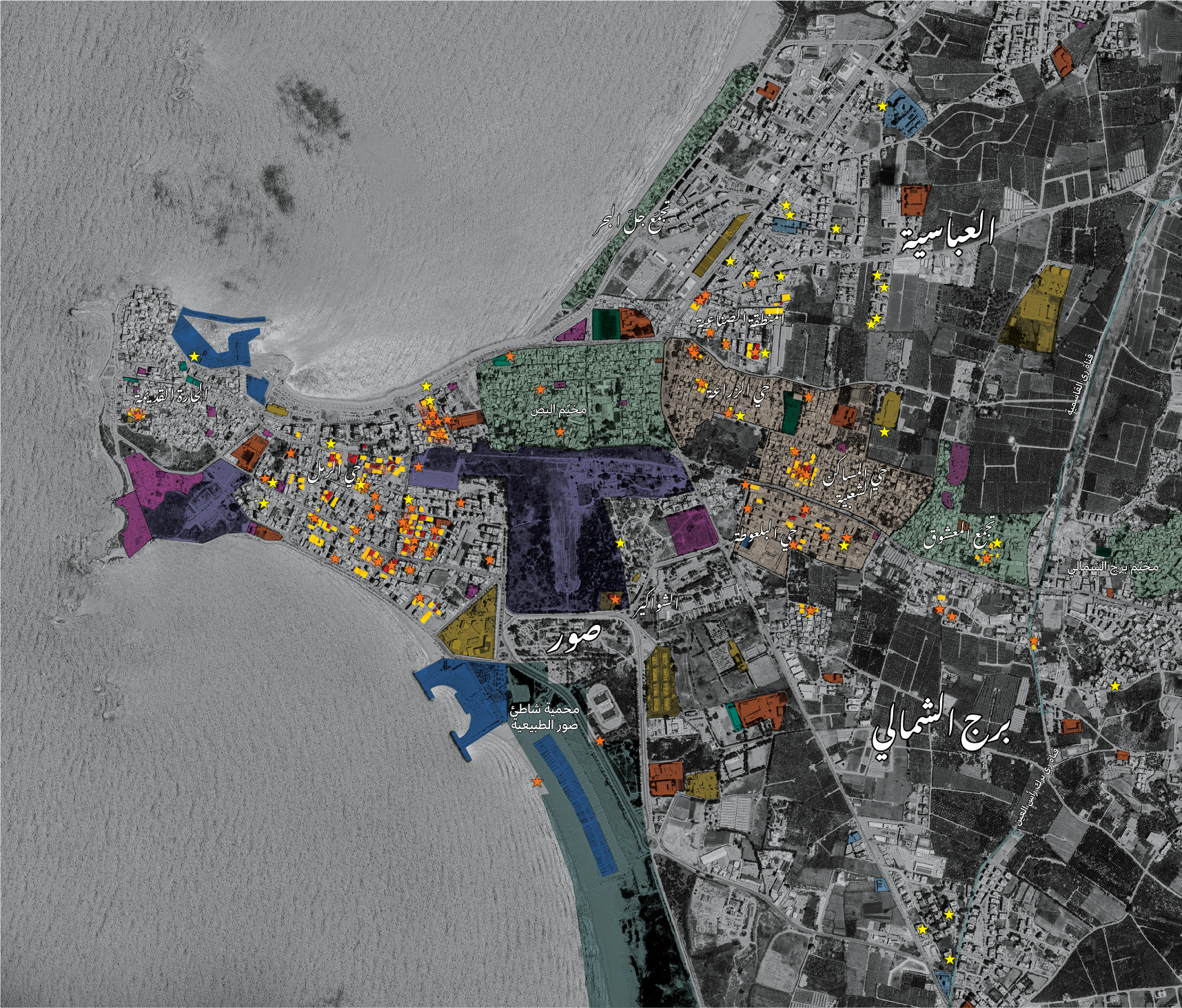
These maps, and the visualizations they contain, offer tools for interpreting the deep scars the war has left on the urban, social, and environmental fabric of southern Lebanon.
The monitoring reveals the volatile and uneven nature of Israeli attacks: villages that were warned and then bombed, towns bombed without warning, communities threatened but not attacked, and others spared from both warnings and attacks despite heavy bombardment in their vicinity. Homes, forests, healthcare and educational facilities, rescue teams, UN forces, and the Lebanese Army were all among the targets.
Across these patterns, a broader objective emerges: to keep southern Lebanon-including areas extending north of the Litani River-under constant threat, destabilizing livelihoods and undermining the conditions necessary for everyday life.
Beyond documenting destruction, these maps provide a basis for imagining recovery. They help reveal how violence reshapes relationships between people and place, while offering a framework to question the exclusions often reproduced through reconstruction processes. In this sense, mapping becomes both a tool of research and accountability and a means of envisioning an urban recovery that extends beyond material reconstruction to address questions of justice, rights, dignity, and collective life.